The first three astrofixes were observed using the well known method of position lines to obtain latitude and longitude (War Office, 1958). The main advantage of the position line method is that stars can be observed through breaks in the cloud, preferably in each quadrant and a fix obtained in relatively bad weather. However, before the days of programmable hand-held calculators, the calculations using logarithms were lengthy with the result, good or bad, not being known until the position lines were plotted.
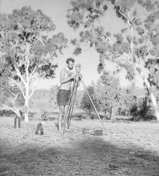
With clear skies more often than not during the May to October dry season in the latitudes of central Australia, a switch was made to Rimington's method of observing meridian transits for longitude and zenith distances for latitude (Rimington, 1944). The advantages are that observations to 10 stars, 5 pairsof north and south stars, could be done in 1-1½ hours starting soon after identifying Sigma Octantis which allowed the meridian to be set and the computations for three out of the five pairs were often completed during supper. Figure 2.
Rimington's method depends on the fact that if the assumed meridian was the true meridian then the observed difference in sidereal times of transit between a pair of stars, one north and the other south, would equal the difference between the Right Ascensions of that pair of stars.
Corrections for the difference between assumed and true meridian are made to the times of transit of the stars to give Local Sidereal Time of transit which minus Greenwich Sidereal Time of transit equals longitude expressed in time.
The observing method consisted of recording the times the star crossed the horizontal stadia wires, early stadia face right and late stadia face left with the mean giving time of transit of the assumed meridian. The zenith distance, ZD, was read on face left and a simple calculation of ZD plus correction for refraction and the star's declination gives latitude.
The skill in observing required accurate timing with stopwatch comparisons against the chronometer then transiting the telescope, adjusting diagonal eyepieces, setting the meridian, locating the star, reading ZD then stopwatch and chronometer comparisons for the late stadia crossing. For a star near the celestial equator that series of operation had to be done in about 2 minutes compared with the south stars which dawdled between the stadia wires taking 3-6 minutes or more to cross.
The astrofix was accepted if three pairs of star observations were within 0.3 seconds of time for longitude and the latitude range for the north and for the south stars did not exceed five seconds of arc. The estimated reliability of an astrofix position was about 100 metres. With practical experience some refinements were made to Rimington's original method, such as the Sigma Octantis graph for obtaining azimuth (Division of National Mapping c 1970).
Special care needed to be taken in positively identifying the astrofix or reference point on the aerial photograph as many an accurate observation has been wasted as map control because of an inaccurate photo identification. Before leaving for the next astro it was usual to do a locality sketch and mark the station by blazing a suitable tree with a broad arrow, NM for National Mapping, the observer's initial and astrofix number. See Figure 3. Back in the office the complete observation of 5 pairs was computed, checked and a summary sheet prepared for the survey records. See Figure 4.
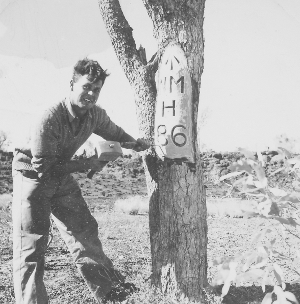
Figure 3. Eric Crisp marking a Coolabah tree at
Flemington Racecourse claypan near the centre of
the Mount Drummond map area previously named
Murphys Creek.
"1949 May 18 Wednesday. 0830 hours moved on still west of north to floodout of Hanlon Creek. Bad stake country in floodout and both Commers staked. Detoured north east then north around floodout, west for 3 miles then west of north to Poison Creek floodout. Bad scrub all the way and both Commers and Jeep staked Mended 2 Jeep tubes - tough job as tyres had not been off before and they were very rusty. No observation - 8/10th cloud. Over the air heard of rain down Alice way and strong wind sprang up later taking the aerial, breaking 3 sections.The official diary entries read:
May 19 Thursday. Brought comps up to date, mended staked tyres, identified position on photos and prepared for the night's observation as the weather was clearing. Yarned for a long time after lunch - talking war and fight! Started observing early and completed comps about 10 o'clock then helped Ted sort out his pairs as for some reason they strayed quite a bit although the mean was close to mine and his adopted meridian very close to true. No contact with the wireless - haven't got the output. NMH 77, Poison Creek floodout."
"May Wednesday 18th. Moved on to Poison Creek floodout via Hanlon Creek floodout. Six staked tyres between Hanlon and Poison Creeks. No ob. 8110th cloud Aerial broken by wind.
Thursday 19th. Repaired tyres - Jeep tyres much worn. Observed Station No. NMH77."