Abstract
Accepting the proposition that maps provide information which usually lessens the uncertainty of what lies outback of the ranges and beyond the creeks, the dry lakes and over the sandridges, then this paper, in keeping with the Congress theme of "Reducing Remoteness", reviews the Division of National Mapping's field survey programme of astronomical observations for fixing position (astrofixes), barometer heighting and airphoto identification used for compilation of the 4 mile to 1 inch and 1:250 000 R502 map series. Background information is given for the 1948-52 period, when most of the astrofixes were done and it is hoped this account may also serve to cover the gap in recording Natmap's field surveying activities prior to Mr. R.A. Ford's excellent series of articles in "The Australian Surveyor" in 1979.
Introduction
At a roadhouse called "Frewena" about 155 km east of Tennant Creek on the Barkly Highway to Camooweal there is a survey station NM H1, an astrofix, the first survey point established on 13 May 1948 by the National Mapping Section as it was then known. So the survey activities of Natmap began. In fact this station was recorded first as DH1 but, because of the similarity to existing traverse stations on the Stuart Highway which included the family name initial of the surveyor who observed particular sections, for example 'H' for Hope, 'K' for Knight, 'R' for Rimington and 'T' for Tidy, it was decided to incorporate NM for National Mapping when numbering astros. Some years later the survey station numbering system was changed with the letter 'A' denoting astro following NM, and another letter corresponding to the State or Territory where the astro was located, for example, NMA/G/123 for a Natmap astro in the Northern Territory. |
The Natmap party of 3 - Messrs G.R.L. Rimington, Chief Topographic Surveyor, D.R. Hocking, Field Assistant (Survey) and D.V. McKay, Driver (Survey) left Melbourne on 3 May 1948 travelling in a Chevrolet 1 ton truck to Quorn where the truck was loaded on to a flat-top rail wagon for Alice Springs. The survey party spent a most interesting and enjoyable 2 days on the "Ghan" train trip from Quorn to the Alice - a journey of some 1200 kilometres. Where else will a train driver wait while passengers replenish their "provisions" from the wayside bush pubs at Maree, Oodnadatta and so on along the line?
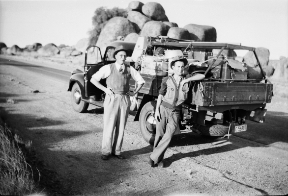
After purchasing stores and collecting some important items of equipment, including a Wild T2 Theodolite No 7028 from the survey store in the old jail with the aid of Mr. Ted Warton, Assistant Surveyor with Lands and Survey, the party left the Alice and headed north along the bitumen - the Stuart Highway. See Figure 1.The Survey party hands usually gave a cheer when travelling north on the bitumen past Kelly Well which is about 20 degrees south latitude because the basic wage in 1948 rose from £6-1-0 south to £6-10-9 north of the 20th parallel. The marginal differences per week in addition to the basic wage were:
Chainman, survey
Survey hand
Driver, survey |
£0-19-0
£0-10-0
£2-18-0 |
|